Community Corner
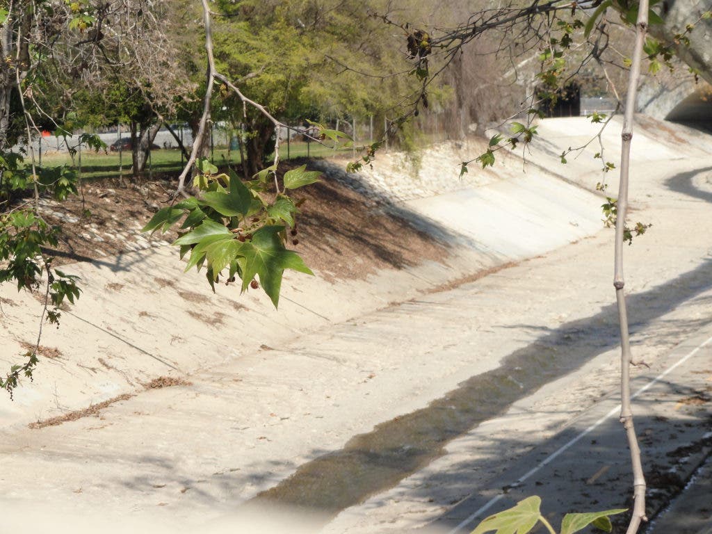
The Arroyo Not So Seco
The columnist tracks the path of one of Highland Park's most important historical natural resources, the Arroyo Seco.


Highland Park, like every great city of the world, was built adjacent to a source of water. The Arroyo Seco is such a source.
It may be seco (or, dry) now, but this was once one of two main sources of water for the city of Los Angeles, and still could be.
But where does this water come from?
Find out what's happening in Highland Park-Mount Washingtonwith free, real-time updates from Patch.
To see the source of the Arroyo Seco yourself, you will have to go up into the mountains, behind Mt. Wilson. Unfortunately, Angeles Crest Highway is closed. You can get back there by going to Highway 14, towards Palmdale, and then taking N3 toward Mt. Wilson.
The official source or headwaters of the Arroyo Seco is Bear Canyon. This canyon, while not far away, is only accessible by hiking. If you aren’t a big hiker, a great place to see where the waters for the arroyo start is Switzer Falls, which is a good hike for the casual hiker. The falls are falling most of the year, so please go and enjoy this wonderful bit of nature not too far from where you are right now, as the crow flies. You’ll have to drive, but what’s time and gas when you will see beauty and history.
Find out what's happening in Highland Park-Mount Washingtonwith free, real-time updates from Patch.
This is in the Angeles National Forest where you'll need a parking/hiking pass. That link will show you a map of where the canyon and the falls are as well as other helpful information.
You’ll also see on the map that you can drive to Mt. Wilson, where the big TV broadcast antennas are, and you can get a great view of the arroyo, San Gabriel Valley, most of L.A. and on a clear day Catalina Island. On an extremely clear day, you'll be able to spot Santa Barbara Island. Also, up on Mt. Wilson is the historic telescope where Hubble figured out the shape of the universe.
The waters of the arroyo come down from the mountains along the same canyon as Highway 2, the Crest Highway, and you can see it most of the way down.
While it is called the Arroyo Seco, seco being a Spanish word for dry, in this mountain section, the water flows most of the year in most years.
Right about where you would lose site of it, the Arroyo Seco meets up with a few other creeks in what is called the upper mountain watershed, on this side of the San Gabriel Mountains. This area is known the Hahamongna Watershed.
Hahamongna, like topanga, cucamonga, pacoima, cahuenga, and some say azusa, are all Tongva words, the language of the first people in our neighborhood.
Here the arroyo meets other waters and spreads into what is called an alluvial plain, a geological formation that is said to be rare in California.
Sand gravel and other goodies brought down from the mountain by the arroyo waters leave a wonderful place for animals and plants to grow and frolic.
To give you an idea of the amount of water that once flowed through the area, there are reports of the Tongva fishing for steelhead trout and even salmon in these waters. If anyone has information about that bit of history, please leave it in the comment area below.
In 1920 the Devil’s Gate Dam was built, which helped control the flooding and provide for the water for consumption by the surrounding communities.
Traveling down the arroyo brings us to Brookside Golf Course, the Rose Bowl, and the other facilities that wouldn’t have been able to be built without the Devil’s Gate Dam and the paving of the Arroyo Seco.
Just past the Colorado Blvd. Bridge the arroyo narrows, and a walk, bike ride, or drive will show you beautiful rock formations carved by the waters.
Once those rocks open up, there are many water sources and aquatic features that are interesting.
At 433 Arroyo Dr. in South Pasadena is the home of Don Manuel Garfias, the last Mexican land grant holder in these parts. He built his place by springs that also served as water for a Tongva village.
Here in Highland Park, north of Meridian St. where Milwaukee and Springvale Dr. almost meet, were a couple springs that were the sources of a creek called the North Branch of the Arroyo Seco. This creek then basically went down Aldama St. to meet with the arroyo near .
Behind Burbank Middle School, you’ll find Garvanza Park. Here was a major spring, and the present home of the Highland Reservoir. I’ve read that it is the oldest reservoir in the city. It was declared an Historic Cultural Monument in 1989. If you have information when it was built, please leave that information in the comment area below. I wonder if the spring still provides water for the reservoir.
On the east side of the Arroyo near York Blvd. and Pasadena Avenue, near the equestrian stables, was the Arroyo Verde Springs
Indian Head Springs near the corner of York and Eagle Rock Blvd. are still going strong, and if you buy Sparkletts water, you are drinking from that well.
Yosemite Springs were/are at 226 S. Ave. 54, and were used until recently by the Yosemite Waters bottling company. If you drank Yosemite Water, you were drinking Highland Park water. The plant was recently bought by Sparkletts, and in that grand capitalist tradition, they closed it down.
Near Figueroa and Sycamore Terrace, across from Sycamore Grove Park, was a spring that was home to the White Rock or Rose Spring Water bottling company.
At 4605 Figueroa was the Casa de Adobe Springs, which bottled water in 1915.
Then the arroyo flows to the Los Angeles River, then out to sea.